


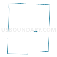
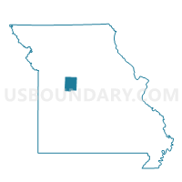
3rd Ward 3rd Precinct, Pettis County, Missouri
About
Outline

Summary
| Unique Area Identifier | 609359 |
| Name | 3rd Ward 3rd Precinct |
| County | Pettis County |
| State | Missouri |
| Area (square miles) | 0.69 |
| Land Area (square miles) | 0.69 |
| Water Area (square miles) | 0.00 |
| % of Land Area | 100.00 |
| % of Water Area | 0.00 |
| Latitude of the Internal Point | 38.69979320 |
| Longtitude of the Internal Point | -93.20519970 |
Maps

Graphs
Select a template below for downloading or customizing gragh for 3rd Ward 3rd Precinct, Pettis County, Missouri


Neighbors
Neighoring Voting District (by Name) Neighboring Voting District on the Map
- 2nd Ward 2nd Precinct, Pettis County, MO
- 2nd Ward 3rd Precinct, Pettis County, MO
- 3rd Ward 1st Precinct, Pettis County, MO
- 3rd Ward 2nd Precinct, Pettis County, MO
- Sedalia East Voting District, Pettis County, MO
Top 10 Neighboring County Subdivision (by Population) Neighboring County Subdivision on the Map
Top 10 Neighboring Place (by Population) Neighboring Place on the Map
Top 10 Neighboring Unified School District (by Population) Neighboring Unified School District on the Map
Top 10 Neighboring State Legislative District Lower Chamber (by Population) Neighboring State Legislative District Lower Chamber on the Map
Top 10 Neighboring State Legislative District Upper Chamber (by Population) Neighboring State Legislative District Upper Chamber on the Map
Top 10 Neighboring 111th Congressional District (by Population) Neighboring 111th Congressional District on the Map
Top 10 Neighboring Census Tract (by Population) Neighboring Census Tract on the Map
- Census Tract 4804, Pettis County, MO (4,554)
- Census Tract 4810, Pettis County, MO (4,480)
- Census Tract 4805, Pettis County, MO (3,030)
- Census Tract 4809, Pettis County, MO (2,846)